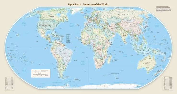
The United Nations General Assembly has backed a major change in how the world is represented on maps, encouraging the wider use of the Equal Earth projection as an alternative to the widely used Mercator projection.
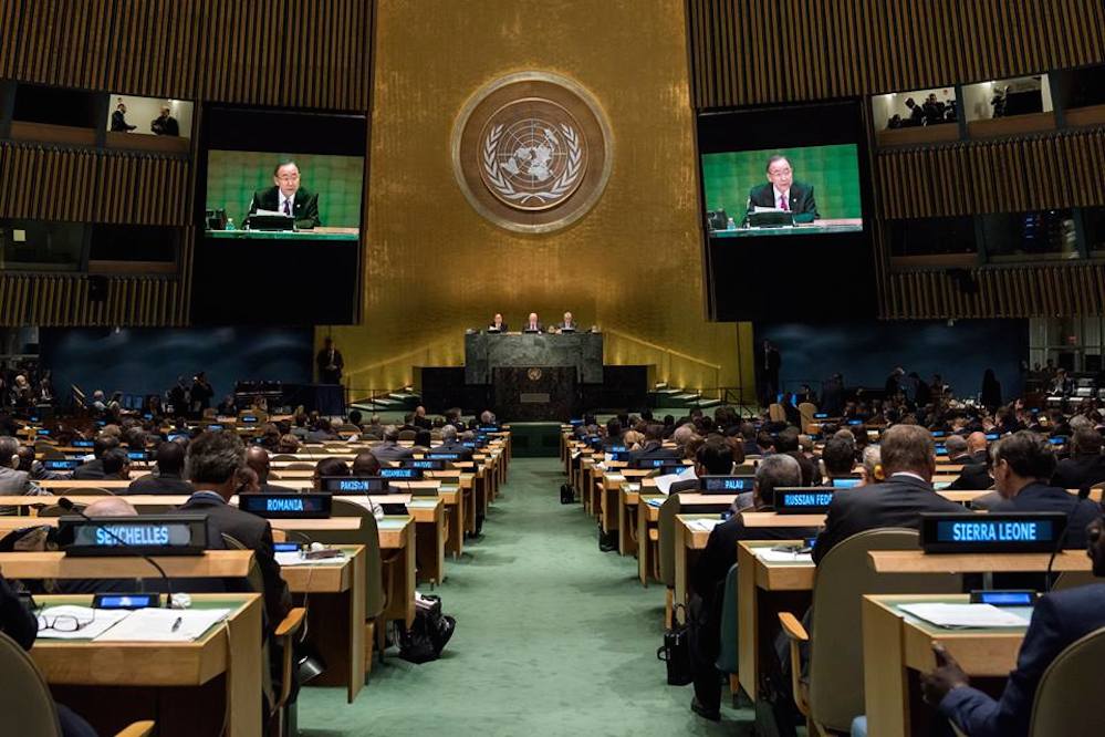
The resolution, adopted on Friday, September 4, 2026, was supported by 164 countries, with the United States voting against and six countries abstaining.
The move follows an African-led campaign spearheaded by Togo and supported by the African Union, calling for a more accurate representation of the relative size of the world's continents.
Why Is the Mercator Map Being Questioned?
The Mercator projection was developed by Flemish cartographer Gerardus Mercator in 1569.
It became highly influential because it was particularly useful for maritime navigation. The projection preserves angles and makes it easier for sailors to plot courses, but this comes with a major trade-off: the relative size of land areas becomes increasingly distorted as locations move away from the Equator.
As a result, countries and regions in the northern and southern extremes of the globe can appear much larger than they actually are.
One of the most famous examples is Greenland.
On a typical Mercator world map, Greenland can appear comparable in size to Africa. In reality, Africa is roughly 14 times larger than Greenland.
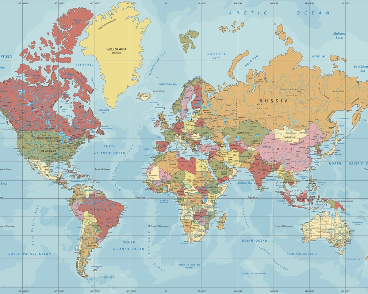
The distortion also affects how Africa, South America and other regions closer to the Equator are visually perceived.
Enter Equal Earth
The Equal Earth projection was designed to address a different problem.
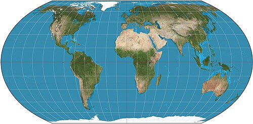
Unlike Mercator, Equal Earth is an equal-area projection, meaning that the relative areas of landmasses are preserved much more accurately.
The projection was developed by cartographers Bojan Šavrič, Tom Patterson and Bernhard Jenny and introduced in 2018/2019.
Its objective is not to make every country look perfectly shaped. Instead, it prioritises representing the relative size of continents and other geographic areas more accurately.
That means Africa appears substantially larger relative to Europe and North America than it does on a Mercator map.
What Did the United Nations Actually Decide?
The UN resolution is important, but it does not mean that Mercator maps have been banned worldwide.
The General Assembly resolution encourages governments, schools, international organisations and technology companies to consider Equal Earth and other equal-area projections when accurate representation of land area is important.
The resolution also recognises that no single flat map can perfectly represent the Earth because the planet is three-dimensional while conventional maps are two-dimensional.
The International Cartographic Association similarly notes that there is no single "correct" world map projection. Different projections make different compromises involving area, shape, distance, direction and appearance.
Mercator therefore remains useful for particular purposes, especially navigation, even though it is not suitable for accurately comparing the areas of continents on a world map.
The Vote
The UN General Assembly adopted the resolution by:
- 164 votes in favour
- 1 vote against
- 6 abstentions
The United States was the only country to vote against the resolution.
Estonia, Georgia, Lithuania, Moldova, Serbia and Ukraine abstained.
The resolution was introduced by Togo on behalf of the African Group, with backing from the African Union.
Togo argued that maps do more than simply display geographical information because they also influence education and how people perceive the world.
Why Africa Is at the Centre of the Debate
The campaign has been strongly connected to concerns about how Africa has historically been represented on commonly used world maps.
Because the Mercator projection expands areas towards the poles and compresses areas closer to the Equator, Africa can appear significantly smaller relative to Europe and North America than its actual landmass would suggest.
The African Union and Togo have argued that changing the way the world is represented can help correct misconceptions that have been reinforced through classrooms, textbooks and commonly used maps.
The initiative has therefore become more than a technical discussion among cartographers. Supporters see it as part of a broader effort to improve the accuracy and fairness of global representation.
Togo's Foreign Minister Robert Dussey described the vote as a significant moment for how the world is represented, arguing that maps influence education, imagination and collective perceptions.
But Is Equal Earth a Perfect Map?
No.
And this is an important part of the story.
There is no perfect flat map of Earth.
The Earth is approximately spherical, and converting its surface onto a flat sheet inevitably introduces some form of distortion.
Mercator preserves angles and directions particularly well for navigation but greatly distorts area at global scale.
Equal Earth does the opposite in one important respect: it preserves relative area much more accurately, but it still introduces distortions in shapes, distances and other geographic properties.
This is why cartographers choose different projections depending on what a map is intended to accomplish.
The International Cartographic Association has emphasised that equal-area projections are particularly appropriate when the purpose is to communicate geographic area or quantities closely related to area.
What Could Change?
The UN resolution could influence how maps are presented in several areas.
Education
Schools and educational publishers could increasingly adopt Equal Earth or other equal-area projections when teaching global geography.
This could give students a more accurate visual understanding of the relative size of continents.
Digital Platforms
Technology companies and online mapping platforms could also consider alternative projections when presenting global-scale maps.
The resolution specifically encourages wider consideration of more accurate projections by technology companies and other institutions.
Media and Publications
News organisations, textbooks, atlases and other publishers may also increasingly use Equal Earth when comparing continental or national land areas.
What Does This Mean for the Map on Your Phone?
Not necessarily an immediate change.
The UN resolution is not a global order requiring Google Maps, Apple Maps or every website to replace Mercator overnight.
Different mapping systems use different projections depending on their purpose.
For example, navigation systems have different requirements from an educational map showing the relative size of African and European countries.
The significance of the UN decision is therefore more about encouraging a shift in how world maps are presented, particularly when the goal is to communicate the true relative size of regions.
Africa Looks Different on Equal Earth
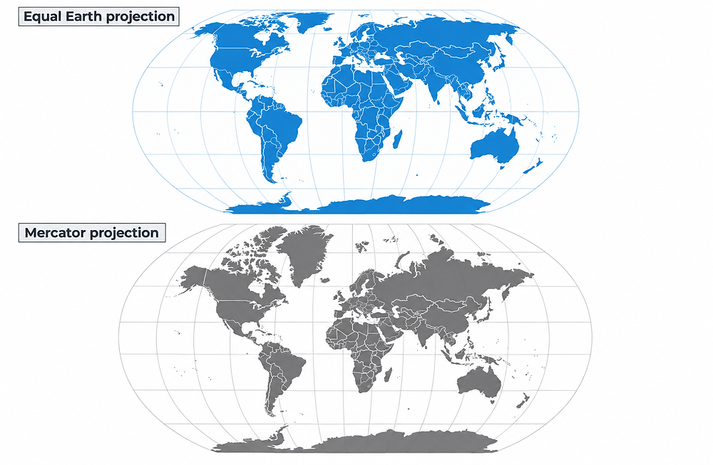
The difference becomes immediately noticeable when the two projections are placed side by side.
On Mercator:
Africa appears smaller and northern regions appear greatly enlarged.
On Equal Earth:
Africa occupies a much larger and more realistic proportion of the world map.
Australia also appears larger relative to the northern continents, while Europe, North America and other high-latitude regions lose some of the visual enlargement associated with Mercator.
A Change in How We See the World
The UN's decision has reopened a debate that has existed among geographers and cartographers for decades: What should a world map actually show?
Should a map prioritise navigation?
Should it preserve shape?
Should it preserve distance?
Or should it show the actual relative size of countries and continents?
There is no single answer.
But the latest UN resolution makes one point clear: when people are comparing the size of regions, a projection that significantly distorts area can create a misleading picture.
The Equal Earth projection offers one alternative.
The UN has now encouraged governments, educational institutions, international organisations and technology companies to give such alternatives greater consideration.
What Happens Next?
The resolution does not force an immediate global transition.
Instead, its impact will depend on how governments, schools, publishers, international organisations and technology companies respond.
Togo has indicated plans to continue the campaign and work with organisations including the African Union and UNESCO, as well as technology companies, on how the initiative can be implemented.
For now, the Mercator projection remains in use, particularly for purposes where its navigational properties are valuable.
But for teaching and communicating the relative size of the world's continents, Equal Earth is likely to become increasingly visible.
The next time you look at a world map, the question may no longer simply be where countries are.
It may also be:
How accurately does the map show the world?
THE TWO MAPS AT A GLANCE
| Feature | Mercator Projection | Equal Earth Projection |
|---|---|---|
| Main strength | Preserves angles and directions | Preserves relative area |
| Developed | 1569 | 2018/2019 |
| Best known use | Navigation and web mapping | World maps and area comparison |
| Continental area | Strongly distorted at high latitudes | Much more accurately represented |
| Africa's relative size | Appears smaller than its true proportion | Much closer to its true proportion |
| Perfect representation? | No | No |

Comments 0
Join the conversation with verified FUTO students.
Verify your JAMB registration number to comment, like and reply.
Loading discussion...